Why Versatility and Problem Solving are Trinity Animation’s Strengths
This article was written by Byron Pockrandt
At Trinity Animation, we take pride in helping our clients and meeting the challenges they bring head on. While most of our work depends on creating beauty stills and animated videos, we occasionally get projects that go beyond our normal scope of work and require formulating a brand new production pipeline to meet the client’s goals. This was the case with our most recent client.
3D Visualization Problem Solving in Action
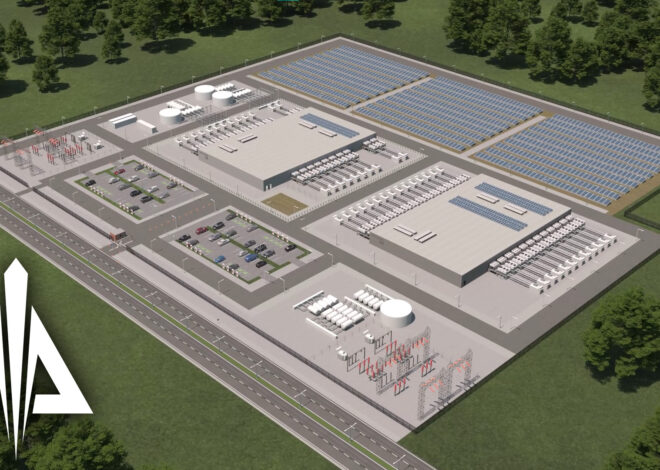
They came to us in hopes that we could revamp and revitalize their 3D map models to help bring in future clients. The client uses these maps in their proprietary security software. These maps were created for schools, hospitals and government buildings to help the security team at these facilities get visual notifications when doors, sensors or alarms go off. While the client had their software code up and running smoothly, the visuals on the screen were unappealing and outdated.
Redesigning and Enhancing 3D Models
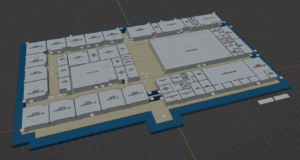
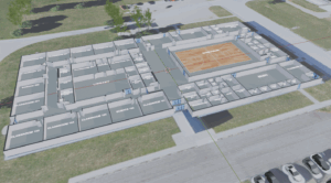
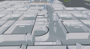
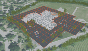
We took on the challenge and went right to work. We took our client’s wish list and whipped up a few concept files of how the new maps could look. After a few rounds of meetings and edits we landed on the initial design. We changed the cubes that represented rooms and transformed them into architectural interior rooms complete with an open door for each room. We added aerial imagery of the building and its surroundings on a ground plane to help make the map look and feel more like a map the general public would identify and connect with. We added simple car models with a few different paint schemes to populate the parking lots and nearby streets. We added a tree model to add even more realism to the map.
Adapting the Production Pipeline
A fun quirk about these maps, the client needed them delivered in a unique file format, an embedded gltf file format to be precise. While we were able to use our pre-existing 3D software, Autodesk 3dsMax, for most of the map making process, 3ds Max unfortunately doesn’t export 3D models as a gltf file natively. So we went to work and researched what software does. We found that Blender supports a plugin that allows for exporting 3D models into gltf embedded files. So our first step was to export the map from 3dsMax and bring it into Blender. We were easily able to do this by exporting the map from 3dsMax as an fbx file. We then imported the fbx file into Blender. From there, we exported the map as an embedded gltf file and sent it to our client.
Overcoming Technical Challenges with Blender
As we started recreating their pre-existing maps, the client came back with an idea to add a grid for the exterior of the buildings for perimeter security. However, the grid planes needed to have a metadata label to flag each grid plane to be invisible. After some more research and a few trials, we found that Blender also supported adding custom metadata properties to individual meshes. However, some maps had hundreds of grid planes and adding the metadata property to each one would take a lot of time. Luckily, we found an old plugin for Blender that allowed us to easily copy the metadata property of one grid plane to all the rest of the grid planes in just a couple clicks, saving us time and saving the client money.
By being fast, efficient, flexible and most importantly problem solvers, we’ve made our client very happy. We’ve created over 30 maps for them in the past 4 months, with many more on the horizon. Although this project required some out of the box ingenuity, it just goes to show how far we’ll go for our clients. Do you have an ambitious project in mind but not sure where to start? Send us an email and let’s strike up a conversation!
Phone: 816-525-0103
Email: sales@trinityanimation.com